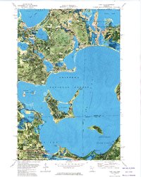
1972 Map of Cass Lake
USGS Topo · Published 1974About this map
The waters of Chippewa Lake and Pike Bay dominate this 1972 orthophotomap, showing the intricate shoreline and complex hydrology of the Leech Lake Indian Reservation. This map uses aerial photography to detail the dense timber and wetland interface between the Chippewa National Forest and neighboring state forests. The settlement of Cass Lake sits at the southern junction of the Burlington Northern Line and the water's edge, serving as a hub for the region's rail and timber interests.
Find a feature on this map
39 named features on this map. Tap any name to fly to it.
Don’t see what you’re looking for? This feature index may not catch every label — zoom into the map to look around manually.
Map Details
Editions of this 1972 Cass Lake Map
This is the sole edition of this map. No revisions or reprints were ever made.
Other maps of this area

1919 · Rosy
USGS Topo · 1:62,500

1954 · Bemidji
USGS Topo · 1:250,000

1957 · Bemidji
USGS Topo · 1:250,000

1958 · Bemidji
USGS Topo · 1:250,000

1971 · Gimmer Lake
USGS Topo · 1:24,000

1971 · Sucker Lakes
USGS Topo · 1:24,000

1971 · Pennington
USGS Topo · 1:24,000

1972 · Turtle River Lake
USGS Topo · 1:24,000
1972 · Pimushe Lake
USGS Topo · 1:24,000

1972 · Pike Bay
USGS Topo · 1:24,000