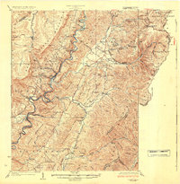
1924 Map of Cass
USGS Topo · Published 1924About this map
The Greenbrier River carves a deep path through Pocahontas County in the early 1920s, serving as the primary corridor for both the Chesapeake & Ohio Greenbrier Branch and the specialized Lumber RR. The town of Cass emerges as a critical industrial hub, with logging lines like the one heading toward Spruce indicating the intensive timber operations of the era. The landscape is dotted with one-room schoolhouses and rural meeting places, from the Hillside School to Hevener Church, reflecting a dispersed but organized mountain community.
Find a feature on this map
104 named features on this map. Tap any name to fly to it.
Don’t see what you’re looking for? This feature index may not catch every label — zoom into the map to look around manually.
Map Details
Editions of this 1924 Cass Map
3 editions found

Other maps of this area

1889 · Beverly
USGS Topo · 1:125,000

1891 · Huntersville
USGS Topo · 1:125,000

1892 · Beverly
USGS Topo · 1:125,000

1893 · Buckhannon
USGS Topo · 1:125,000

1894 · Huntersville
USGS Topo · 1:125,000

1896 · Buckhannon
USGS Topo · 1:125,000

1897 · Buckhannon
USGS Topo · 1:125,000

1901 · Monterey
USGS Topo · 1:125,000

1913 · Pickens
USGS Topo · 1:48,000

1915 · Pickens
USGS Topo · 1:62,500