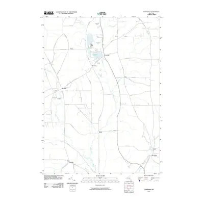
2010 Map of Cassadaga
USGS Topo · Published 2010About this map
Lily Dale sits at the northern edge of this Chautauqua County landscape, an area characterized by its glacial lakes and the meandering Cassadaga Creek. The village of Cassadaga serves as a central hub, flanked by the Cassadaga Lakes and Mud Lake. This 2010 survey illustrates a rural settlement pattern defined by numerous small hamlets and significant genealogy sites, including seven distinct burial grounds such as Christian Cemetery and Bachelor Cemetery. From the southern village of Sinclairville to the crossroads at Pickett Corners, the map documents a network of county routes and local roads like Tarbox Rd and Moon Rd that connect isolated farmsteads. Recreational land use is evident at Camp Gross and Camp Wood E-Lo-Hi, while the hydrography is dominated by the Bear Lake Outlet as it flows toward the valley floor near Centralia.
Find a feature on this map
71 named features on this map. Tap any name to fly to it.
Don’t see what you’re looking for? This feature index may not catch every label — zoom into the map to look around manually.
Map Details
Editions of this 2010 Cassadaga Map
This is the sole edition of this map. No revisions or reprints were ever made.
Other maps of this area

1900 · Dunkirk
USGS Topo · 1:62,500

1900 · Cherry Creek
USGS Topo · 1:62,500

1904 · Chautaqua
USGS Topo · 1:62,500

1905 · Jamestown
USGS Topo · 1:62,500

1941 · Cherry Creek
USGS Topo · 1:62,500

1941 · Chautauqua
USGS Topo · 1:62,500

1942 · Jamestown
USGS Topo · 1:62,500

1943 · Dunkirk
USGS Topo · 1:62,500

1954 · Chautauqua
USGS Topo · 1:24,000

1954 · Ellery Center
USGS Topo · 1:24,000