
1986 Map of Casselton
USGS Topo · Published 1986About this map
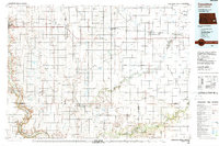
The Sheyenne River and Maple River carve distinct paths through this agricultural expanse of eastern North Dakota, shaping the settlement patterns of Cass, Barnes, and Ransom Counties. In the mid-1980s, the landscape was a grid of township boundaries and rail-oriented towns such as Enderlin, Casselton, and Valley City. This survey illustrates the vital role of water and conservation in the region, featuring the southern reaches of the Sheyenne National Grassland and several wildlife management areas like Mirror Pool State Wildlife Management Area. Cultural landmarks including Little Yellowstone Park and Ft Ransom State Park provide contrast to the industrial footprint of the Burlington Northern and Soo Line railroads. From the Griswold Mine to the Memory Gardens Cem, the map documents a transition from pioneer-era foundations to a modern rural economy.
Find a feature on this map
116 named features on this map. Tap any name to fly to it.
Don’t see what you’re looking for? This feature index may not catch every label — zoom into the map to look around manually.
Map Details
Editions of this 1986 Casselton Map
2 editions found
Other maps of this area

1895 · Lamoure
USGS Topo · 1:125,000

1895 · Fargo
USGS Topo · 1:125,000

1895 · Casselton
USGS Topo · 1:125,000

1897 · Fargo
USGS Topo · 1:125,000

1897 · Tower
USGS Topo · 1:125,000

1897 · Eckelson
USGS Topo · 1:125,000

1897 · Casselton
USGS Topo · 1:125,000

1904 · Wahpeton
USGS Topo · 1:125,000

1907 · Wyndmere
USGS Topo · 1:125,000

1918 · La Moure
USGS Topo · 1:125,000