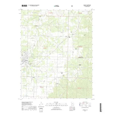
2017 Map of Cassville
USGS Topo · Published 2017About this map
Cassville serves as the focal point of this Barry County landscape, showing the town's street grid and modern expansion alongside traditional landmarks like Oak Hill Cem. The surrounding terrain is defined by the complex drainage systems of Flat Cr and the Roaring River, which carve through various hollows such as Corder Hollow and Rockhouse Hollow. Much of the eastern portion of the map is protected within the Mark Twain National Forest, illustrating the managed transition between rural settlement and conserved woodland. Genealogists will find several burial grounds across the area, including the Quaker Cem and Horner Cem. Unique geographic features are also noted, most notably the Ash Cave Natural Arch and the specialized Timber Line Airpark, reflecting both the natural geological character and the 21st-century infrastructure of this Ozark plateau region.
Find a feature on this map
103 named features on this map. Tap any name to fly to it.
Don’t see what you’re looking for? This feature index may not catch every label — zoom into the map to look around manually.
Map Details
Editions of this 2017 Cassville Map
This is the sole edition of this map. No revisions or reprints were ever made.
Other maps of this area

1927 · Shell Knob
USGS Topo · 1:62,500

1937 · Cassville
USGS Topo · 1:48,000

1942 · Aurora
USGS Topo · 1:62,500

1943 · Monett
USGS Topo · 1:62,500

1944 · Cassville
USGS Topo · 1:62,500

1945 · Harrison
USGS Topo · 1:250,000

1945 · Aurora
USGS Topo · 1:62,500

1949 · Harrison
USGS Topo · 1:250,000

1950 · Shell Knob
USGS Topo · 1:62,500

1954 · Harrison
USGS Topo · 1:250,000