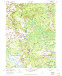
1957 Map of Cassville
USGS Topo · Published 1972About this map
The New Jersey Wildlife and Game Refuge and the headwaters of the Toms River dominate this Central Jersey landscape, where the transition from agriculture to military use and conservation is clearly visible. The map documents the northern reaches of the Fort Dix Military Reservation and the Lakehurst Naval Air Station, contrasting with the numerous Cranberry Bogs that dot the lowlands. Local genealogy and community life center on Cassville and St Vladimirs, the latter featuring Saint Vladimirs Ch.
Find a feature on this map
41 named features on this map. Tap any name to fly to it.
Don’t see what you’re looking for? This feature index may not catch every label — zoom into the map to look around manually.
Map Details
Editions of this 1957 Cassville Map
3 editions found
Other maps of this area

1884 · Whitings
USGS Topo · 1:62,500

1888 · Bordentown
USGS Topo · 1:62,500

1888 · Pemberton
USGS Topo · 1:62,500

1888 · Cassville
USGS Topo · 1:62,500

1888 · Whitings
USGS Topo · 1:62,500

1893 · Bordentown
USGS Topo · 1:62,500

1894 · Cassville
USGS Topo · 1:62,500

1894 · Pemberton
USGS Topo · 1:62,500

1898 · Pemberton
USGS Topo · 1:62,500

1900 · Cassville
USGS Topo · 1:62,500
Featured Places
- Jackson Township, NJ
- Manchester Township, NJ
- Plumsted Township, NJ
- Upper Freehold Township, NJ
- Colliers Mills, Jackson Township