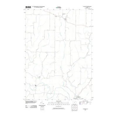
2010 Map of Castalia
USGS Topo · Published 2010About this map
The Turkey River winds through the southern portion of this landscape, anchoring the settlement of Clermont where the Clermont Post Office and Saint Peters Cemetery are located. This quadrangle captures the rural character of Fayette County at the start of the 21st century, defined by a grid of agricultural roads such as Great River Rd and Centennial Rd. To the north, the town of Castalia sits near the intersection of several local routes, served by the Castalia Post Office and flanked by Bloomfield Cemetery and Pleasant View Cemetery.
Find a feature on this map
46 named features on this map. Tap any name to fly to it.
Don’t see what you’re looking for? This feature index may not catch every label — zoom into the map to look around manually.
Map Details
Editions of this 2010 Castalia Map
This is the sole edition of this map. No revisions or reprints were ever made.
Other maps of this area

1901 · Oelwein
USGS Topo · 1:125,000

1906 · Decorah
USGS Topo · 1:125,000

1958 · La Crosse
USGS Topo · 1:250,000

1959 · Dubuque
USGS Topo · 1:250,000

1961 · Dubuque
USGS Topo · 1:250,000

1961 · La Crosse
USGS Topo · 1:250,000

1962 · Dubuque
USGS Topo · 1:250,000

1965 · La Crosse
USGS Topo · 1:250,000

1965 · Elgin
USGS Topo · 1:24,000
1965 · Gunder
USGS Topo · 1:24,000