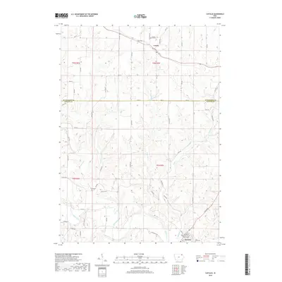
2018 Map of Castalia
USGS Topo · Published 2018About this map
The Turkey River winds through the southern portion of this region, providing a natural anchor for the community of Clermont. Further north, the town of Castalia sits at a higher elevation, surrounded by a complex network of agricultural roads such as Main St and Centennial Rd. The landscape is defined by the sharp transition between the river valley and the dissected uplands, where numerous seasonal and perennial waterways like Quinn Cr, Nutting Cr, and Fitzgerald Cr have carved the terrain. Genealogists will find several burial sites preserved across these rural sections, including Bloomfield Cem and Pleasant View Cem near the northern boundary, as well as Nutting Cem and Saint Peters Cem further south. This 2018 survey illustrates a modern rural landscape where traditional township lines and property access roads like 130th Ave remain central to the area's organization.
Find a feature on this map
64 named features on this map. Tap any name to fly to it.
Don’t see what you’re looking for? This feature index may not catch every label — zoom into the map to look around manually.
Map Details
Editions of this 2018 Castalia Map
This is the sole edition of this map. No revisions or reprints were ever made.
Other maps of this area

1901 · Oelwein
USGS Topo · 1:125,000

1906 · Decorah
USGS Topo · 1:125,000

1958 · La Crosse
USGS Topo · 1:250,000

1959 · Dubuque
USGS Topo · 1:250,000

1961 · Dubuque
USGS Topo · 1:250,000

1961 · La Crosse
USGS Topo · 1:250,000

1962 · Dubuque
USGS Topo · 1:250,000

1965 · La Crosse
USGS Topo · 1:250,000

1965 · Elgin
USGS Topo · 1:24,000
1965 · Gunder
USGS Topo · 1:24,000