1966 Map of Castaneda Hills
USGS Topo · Published 1967About this map
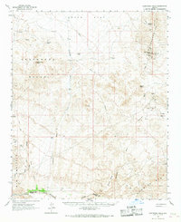
The McCracken Mts and the Raw Hide Mts dominate this mid-century desert landscape, illustrating a region defined by remote mining interests and ephemeral watercourses. In the northeast, the McCracken Mine and scattered prospects near McCracken Peak reflect the area's geological draws, while isolated outposts like Keenan Camp and Rockhouse Cabin provide evidence of human habitation in a demanding environment. The drainage network of Mohave Wash and Castaneda Wash cuts through the territory toward the Bill Williams River at the southern border, which serves as the boundary between Mohave Co and Yuma Co. Infrastructure is sparse, characterized by a Pipeline bisecting Dutch Flat and a network of Jeep Trails that link vital water sources like Bateman Spring and cattle infrastructure including Buckhorn Tank.
Find a feature on this map
30 named features on this map. Tap any name to fly to it.
Don’t see what you’re looking for? This feature index may not catch every label — zoom into the map to look around manually.
Map Details
Editions of this 1966 Castaneda Hills Map
This is the sole edition of this map. No revisions or reprints were ever made.
Other maps of this area

1911 · Parker
USGS Topo · 1:125,000

1923 · Signal
USGS Topo · 1:250,000

1927 · Buck Mountains
USGS Topo · 1:62,500

1929 · Buck Mountains
USGS Topo · 1:62,500

1942 · Signal
USGS Topo · 1:250,000

1943 · Giers Basin
USGS Topo · 1:62,500

1950 · Prescott
USGS Topo · 1:250,000

1954 · Needles
USGS Topo · 1:250,000

1954 · Prescott
USGS Topo · 1:250,000

1956 · Needles
USGS Topo · 1:250,000