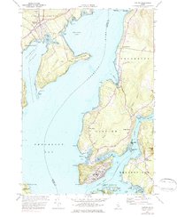
1973 Map of Castine
USGS Topo · Published 1984About this map
The historic peninsula of Castine serves as the focal point of this 1970s coastal survey, showcasing its unique position at the confluence of Penobscot Bay and the Bagaduce River. The town's maritime legacy is evident through the campus of the Maritime Academy and the navigational significance of Dice Head. Traces of earlier military history remain visible at Ft George and the British Canal, while the interior of the peninsula reveals a landscape of small orchards and local landmarks like the Adams Sch and Castine Cem. Across the water, the Bangor and Aroostook rail corridor cuts through Stockton Springs near Cape Jellison. This topography reflects a mid-coast Maine economy transitioning from its heavy industrial and shipping roots toward the preservation of its colonial and maritime heritage, with small settlements like West Penobscot and West Brooksville dotting the harbor-ringed landscape.
Find a feature on this map
78 named features on this map. Tap any name to fly to it.
Don’t see what you’re looking for? This feature index may not catch every label — zoom into the map to look around manually.
Map Details
Editions of this 1973 Castine Map
3 editions found
Other maps of this area

1900 · Orland
USGS Topo · 1:62,500

1900 · Bucksport
USGS Topo · 1:62,500

1902 · Bucksport
USGS Topo · 1:62,500

1902 · Castine
USGS Topo · 1:62,500

1904 · Castine
USGS Topo · 1:62,500

1904 · Bluehill
USGS Topo · 1:62,500

1905 · Penobscot Bay
USGS Topo · 1:125,000

1941 · Castine
USGS Topo · 1:62,500

1942 · Orland
USGS Topo · 1:62,500

1942 · Bucksport
USGS Topo · 1:62,500