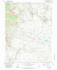
1983 Map of Castle Dale
USGS Topo · Published 1983About this map
The Emery County settlements of Orangeville and Castle Dale dominate this 1980s landscape, illustrating a high-desert community shaped by a complex irrigation network. The transition from the high-elevation Buzzard Bench and Cedar Bench down to the valley floor is managed by an intricate system of waterways, including the Clipper Western Canal, Mammoth Canal, and the notable Cottonwood Creek Siphon. This infrastructure supported both the agricultural life of the valley and the growing industrial presence marked by the Power Plant and nearby Conveyor system.
Find a feature on this map
38 named features on this map. Tap any name to fly to it.
Don’t see what you’re looking for? This feature index may not catch every label — zoom into the map to look around manually.
Map Details
Editions of this 1983 Castle Dale Map
This is the sole edition of this map. No revisions or reprints were ever made.
Other maps of this area

1885 · Manti
USGS Topo · 1:250,000

1886 · Price River
USGS Topo · 1:250,000

1895 · Manti
USGS Topo · 1:250,000

1896 · Price River
USGS Topo · 1:250,000

1923 · Castle Dale
USGS Topo · 1:62,500

1923 · Hiawatha
USGS Topo · 1:62,500

1925 · Castle Dale
USGS Topo · 1:62,500

1925 · Hiawatha
USGS Topo · 1:62,500

1956 · Price
USGS Topo · 1:250,000

1960 · Price
USGS Topo · 1:250,000