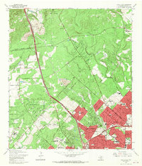
1967 Map of Castle Hills
USGS Topo · Published 1969About this map
The San Antonio Corporate Boundary pushes northward into the limestone hills of Bexar County in this late-sixties survey, capturing a landscape in transition. While the suburban grid of Castle Hills and Hollywood Park expands rapidly, the northern reaches remain dominated by the Leon Springs Military Reservation and the sprawling acreage of the Oak Hills Country Club. The Southern Pacific rail line cuts a straight path through the territory, passing the former site of Olga and the established crossroads at Beckmann. Local landmarks like the Dollar Downs Racetrack and the growing SW Texas Medical Center indicate the region's shift from rural ranching and quarrying toward a modern metropolitan hub. Smaller community anchors, including the Locke Hill Cemetery and Lockhill School, provide essential reference points for genealogists tracking the area's early family settlements.
Find a feature on this map
66 named features on this map. Tap any name to fly to it.
Don’t see what you’re looking for? This feature index may not catch every label — zoom into the map to look around manually.
Map Details
Editions of this 1967 Castle Hills Map
2 editions found
Other maps of this area

1953 · Otis Ridge
USGS Topo · 1:24,000

1953 · Culebra Hill
USGS Topo · 1:24,000

1953 · San Antonio West
USGS Topo · 1:24,000

1953 · Bulverde
USGS Topo · 1:24,000

1953 · San Antonio East
USGS Topo · 1:24,000

1953 · Longhorn
USGS Topo · 1:24,000

1953 · Helotes
USGS Topo · 1:24,000

1953 · Castle Hills
USGS Topo · 1:24,000

1953 · Van Raub
USGS Topo · 1:24,000

1954 · San Antonio
USGS Topo · 1:250,000