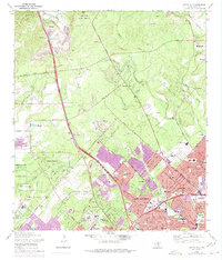
1967 Map of Castle Hills
USGS Topo · Published 1975About this map
San Antonio expands northward into the brushland of the Edwards Plateau in this mid-century topographic record. The landscape is defined by the rapid conversion of ranching land into suburban enclaves like Castle Hills and Shavano Park, where many streets are already established while others are shown as planned extensions in purple. The Southern Pacific railroad line cuts through the western portion, passing the historic Olga (Site) and the settlement of Beckmann, where active quarry operations and gravel pits signal the material demands of the era's construction boom.
Find a feature on this map
127 named features on this map. Tap any name to fly to it.
Don’t see what you’re looking for? This feature index may not catch every label — zoom into the map to look around manually.
Map Details
Editions of this 1967 Castle Hills Map
2 editions found
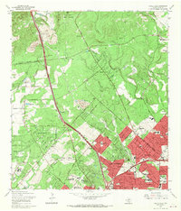
Other maps of this area

1953 · Otis Ridge
USGS Topo · 1:24,000

1953 · Culebra Hill
USGS Topo · 1:24,000

1953 · San Antonio West
USGS Topo · 1:24,000

1953 · Bulverde
USGS Topo · 1:24,000

1953 · San Antonio East
USGS Topo · 1:24,000

1953 · Longhorn
USGS Topo · 1:24,000

1953 · Helotes
USGS Topo · 1:24,000

1953 · Castle Hills
USGS Topo · 1:24,000

1953 · Van Raub
USGS Topo · 1:24,000

1954 · San Antonio
USGS Topo · 1:250,000