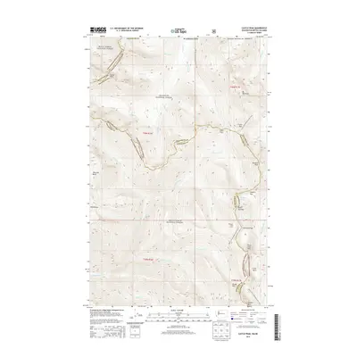
2014 Map of Castle Peak
USGS Topo · Published 2014About this map
Mount Baker National Forest and Okanogan National Forest converge at the international boundary in this high-altitude wilderness survey. The Pacific Crest National Scenic Trail winds north-to-south through the terrain, crossing through Castle Pass and Woody Pass while navigating the steep drop of the Devils Stairway near Hopkins Lake. The landscape is defined by its dramatic verticality, from the 8,000-foot summit of Castle Peak to the deep drainages of Three Fools Creek and Castle Fork. Localized landmarks such as Mountain Home Camp and the high basins of Elbow Basin, Welcome Basin, and Coney Basin suggest a region utilized primarily for backcountry recreation and high-elevation passage. The proximity to the Canadian border is marked by the presence of United States of America labels along the northern boundary, where headwaters like Princess Creek and Winthrop Creek begin their descent.
Find a feature on this map
46 named features on this map. Tap any name to fly to it.
Don’t see what you’re looking for? This feature index may not catch every label — zoom into the map to look around manually.
Map Details
Editions of this 2014 Castle Peak Map
This is the sole edition of this map. No revisions or reprints were ever made.
Other maps of this area

1920 · Slate Pass
USGS Topo · 1:125,000

1955 · Concrete
USGS Topo · 1:250,000

1958 · Concrete
USGS Topo · 1:250,000

1962 · Concrete
USGS Topo · 1:250,000

1969 · Skagit Peak
USGS Topo · 1:24,000

1969 · Frosty Creek
USGS Topo · 1:24,000
1969 · Pasayten Peak
USGS Topo · 1:24,000
1969 · Jack Mtn
USGS Topo · 1:24,000
1969 · Shull Mtn.
USGS Topo · 1:24,000

2002 · Pasayten Peak
USGS Topo · 1:24,000