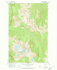
1969 Map of Jack Mtn
USGS Topo · Published 1973About this map
Jack Mountain dominates this high-altitude landscape within the Mt Baker National Forest, its peaks and ridgelines surveyed just as the region was being formally organized into modern conservation zones. The 1969 field check reveals a network of high-country routes including the long Pack Trail that crosses through Dry Creek Pass and passes near the Bear Skull Shelter. The map illustrates a complex drainage system where Devils Creek and its many tributaries, such as North Fork Devils Creek and Middle Fork, carve through the steep terrain between Spratt Mountain and Devils Dome. This document captures the boundary lines for the newly established Pasayten Wilderness and the Ross Lake National Recreation Area, showing the transition from general forest management to specific wilderness protection in the North Cascades.
Find a feature on this map
22 named features on this map. Tap any name to fly to it.
Don’t see what you’re looking for? This feature index may not catch every label — zoom into the map to look around manually.
Map Details
Editions of this 1969 Jack Mtn Map
2 editions found
Other maps of this area

1920 · Slate Pass
USGS Topo · 1:125,000

1955 · Concrete
USGS Topo · 1:250,000

1958 · Concrete
USGS Topo · 1:250,000

1962 · Concrete
USGS Topo · 1:250,000

1963 · Azurite Peak
USGS Topo · 1:24,000

1963 · Crater Mountain
USGS Topo · 1:24,000

1963 · Ross Dam
USGS Topo · 1:24,000

1969 · Skagit Peak
USGS Topo · 1:24,000
1969 · Shull Mtn.
USGS Topo · 1:24,000
1969 · Pumpkin Mtn.
USGS Topo · 1:24,000