
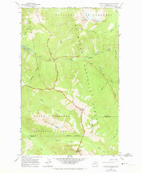
1963 Map of Crater Mountain
USGS Topo · Published 1965About this map
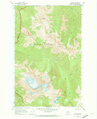
Mt Baker National Forest terrain dominates this 1963 survey, where high-altitude wilderness meets the upper reaches of the Skagit River watershed. The map details the complex geography of the North Cascades before the full expansion of the regional park system, centered on the towering Crater Mountain and its active Jerry Glacier. In the northwest, the Ross Lake Spillway marks the impact of hydroelectric development on the landscape, with the Ruby Arm reaching deep into the mountain valleys. Navigation through this formidable environment is defined by the Cascade Crest Trail and various alternates, connecting remote points like the Granite Creek Guard Station and the high elevations of McMillan Park. Significant peaks and ridges, including Elija Ridge and Gabriel Peak, are delineated alongside the Whatcom and Skagit County line, reflecting the area's role as a critical wilderness boundary.
Find a feature on this map
37 named features on this map. Tap any name to fly to it.
Don’t see what you’re looking for? This feature index may not catch every label — zoom into the map to look around manually.
Map Details
Editions of this 1963 Crater Mountain Map
2 editions found
Other maps of this area

1920 · Slate Pass
USGS Topo · 1:125,000

1955 · Concrete
USGS Topo · 1:250,000

1958 · Concrete
USGS Topo · 1:250,000

1962 · Concrete
USGS Topo · 1:250,000

1963 · Azurite Peak
USGS Topo · 1:24,000
1963 · Mt. Arriva
USGS Topo · 1:24,000
1963 · Forbidden Peak
USGS Topo · 1:24,000
1963 · Mt Logan
USGS Topo · 1:24,000

1963 · Ross Dam
USGS Topo · 1:24,000
1969 · Jack Mtn
USGS Topo · 1:24,000