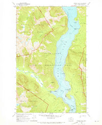
1969 Map of Pumpkin Mtn.
USGS Topo · Published 1973About this map
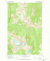
Ross Lake dominates this rugged North Cascades corridor, where the Skagit River was transformed by the high-elevation reservoir system. At the time of this 1969 field check, the landscape was primarily managed for recreation and conservation, divided between the North Cascades National Park, the Ross Lake National Recreation Area, and the Pasayten Wilderness. The map reveals the intricate network of backcountry access points, including the Big Beaver Trail and several remote campsites like Spencer Camp and Rainbow Point Campground. Significant landmarks such as Pumpkin Mtn and the isolated Little Jerusalem Island rise above the water, while the Gaging Station on Beaver Creek indicates the ongoing hydrologic monitoring of the watershed. This sheet captures a wilderness area before modern usage patterns shifted, preserving the locations of early pack ways like the Pierce Mountain (Pack) Way and numerous high-altitude water bodies including Skymo Lake and No Name Lake.
Find a feature on this map
43 named features on this map. Tap any name to fly to it.
Don’t see what you’re looking for? This feature index may not catch every label — zoom into the map to look around manually.
Map Details
Editions of this 1969 Pumpkin Mtn. Map
2 editions found

Other maps of this area

1920 · Slate Pass
USGS Topo · 1:125,000

1955 · Concrete
USGS Topo · 1:250,000

1958 · Concrete
USGS Topo · 1:250,000

1962 · Concrete
USGS Topo · 1:250,000
1963 · Crater Mountain
USGS Topo · 1:24,000

1963 · Diablo Dam
USGS Topo · 1:24,000
1963 · Ross Dam
USGS Topo · 1:24,000
1969 · Skagit Peak
USGS Topo · 1:24,000

1969 · Mt Prophet
USGS Topo · 1:24,000
1969 · Jack Mtn
USGS Topo · 1:24,000