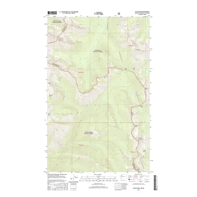
2017 Map of Castle Peak
USGS Topo · Published 2017About this map
Mount Baker National Forest and Okanogan National Forest converge in this high-altitude landscape along the border of Whatcom Co and Okanogan County. The map provides a look at the intersection of two major wilderness thoroughfares: the Pacific Crest National Scenic Trail and the Pacific NW National Scenic Trail. These routes navigate a landscape defined by significant summits like Castle Peak, Mt Winthrop, and Three Fools Peak. Numerous glacial basins and high passes dictate the topography, with notable crossing points such as Castle Pass, Frosty Pass, and Woody Pass. Water features are abundant throughout the drainages, including Hopkins Lake and the headwaters of Three Fools Cr, Castle Cr, and Winthrop Cr, illustrating the complex hydrology of the North Cascades. The map also identifies remote landmarks like the Devils Stairway and Lakeview Ridge, which serve as vital reference points for backcountry navigation and modern wilderness management.
Find a feature on this map
47 named features on this map. Tap any name to fly to it.
Don’t see what you’re looking for? This feature index may not catch every label — zoom into the map to look around manually.
Map Details
Editions of this 2017 Castle Peak Map
This is the sole edition of this map. No revisions or reprints were ever made.
Other maps of this area

1920 · Slate Pass
USGS Topo · 1:125,000

1955 · Concrete
USGS Topo · 1:250,000

1958 · Concrete
USGS Topo · 1:250,000

1962 · Concrete
USGS Topo · 1:250,000

1969 · Skagit Peak
USGS Topo · 1:24,000

1969 · Frosty Creek
USGS Topo · 1:24,000
1969 · Pasayten Peak
USGS Topo · 1:24,000
1969 · Jack Mtn
USGS Topo · 1:24,000
1969 · Shull Mtn.
USGS Topo · 1:24,000

2002 · Pasayten Peak
USGS Topo · 1:24,000