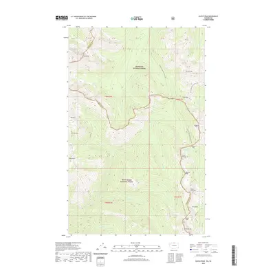
2020 Map of Castle Peak
USGS Topo · Published 2020About this map
Okanogan National Forest and Mount Baker National Forest converge in this high-altitude landscape where the Pacific Crest National Scenic Trail winds through some of the most remote geography in the Cascade Range. The map delineates the boundary between Whatcom and Okanogan counties, following the crest of the mountains through landmark points such as Castle Pass and Woody Pass. This area is characterized by a dense network of glacial drainage, with named waters like Three-Fools Cr and Castle Cr flowing from numerous basins.
Find a feature on this map
50 named features on this map. Tap any name to fly to it.
Don’t see what you’re looking for? This feature index may not catch every label — zoom into the map to look around manually.
Map Details
Editions of this 2020 Castle Peak Map
This is the sole edition of this map. No revisions or reprints were ever made.
Other maps of this area

1920 · Slate Pass
USGS Topo · 1:125,000

1955 · Concrete
USGS Topo · 1:250,000

1958 · Concrete
USGS Topo · 1:250,000

1962 · Concrete
USGS Topo · 1:250,000

1969 · Skagit Peak
USGS Topo · 1:24,000

1969 · Frosty Creek
USGS Topo · 1:24,000
1969 · Pasayten Peak
USGS Topo · 1:24,000
1969 · Jack Mtn
USGS Topo · 1:24,000
1969 · Shull Mtn.
USGS Topo · 1:24,000

2002 · Pasayten Peak
USGS Topo · 1:24,000