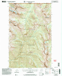
2002 Map of Castle Peak
USGS Topo · Published 2006About this map
The Pacific Crest National Scenic Trail winds through the high-elevation terrain of the Pasayten Wilderness, marking a significant corridor for recreation and preservation at the start of the 21st century. This landscape, straddling the border between Mt Baker - Snoqualmie National Forest and Okanogan National Forest, is defined by its network of steep ridges and drainages. Hikers and researchers can trace paths through Woody Pass and Castle Pass, or follow the Lakeview Ridge Trail past the precarious Devils Stairway. Significant summits like Castle Peak and Mount Winthrop anchor the geography, while remote outposts such as Mountain Home Camp provide context for wilderness management and backcountry travel. The survey also captures the drainage patterns of Castle Creek and Three Fools Creek, reflecting the intricate hydrology of the North Cascades along the international boundary between British Columbia and Washington.
Find a feature on this map
49 named features on this map. Tap any name to fly to it.
Don’t see what you’re looking for? This feature index may not catch every label — zoom into the map to look around manually.
Map Details
Editions of this 2002 Castle Peak Map
This is the sole edition of this map. No revisions or reprints were ever made.
Other maps of this area

1920 · Slate Pass
USGS Topo · 1:125,000

1955 · Concrete
USGS Topo · 1:250,000

1958 · Concrete
USGS Topo · 1:250,000

1962 · Concrete
USGS Topo · 1:250,000

1969 · Skagit Peak
USGS Topo · 1:24,000

1969 · Frosty Creek
USGS Topo · 1:24,000
1969 · Pasayten Peak
USGS Topo · 1:24,000
1969 · Jack Mtn
USGS Topo · 1:24,000
1969 · Shull Mtn.
USGS Topo · 1:24,000

2002 · Pasayten Peak
USGS Topo · 1:24,000