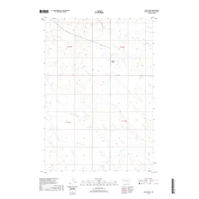
2017 Map of Castle Rock
USGS Topo · Published 2017About this map
Castle Rock stands as the primary landmark in this section of Butte County, overseeing a landscape defined by an intricate network of drainage basins. The map illustrates a high-plains environment where water management and cattle ranching are central to the geography, evidenced by the convergence of Frog Cr and Buck Pasture Cr. The southern half of the quadrangle is dominated by the meandering paths of Middle Cr and Willow Cr, highlighting the importance of these seasonal waterways in an otherwise arid rangeland. Rural infrastructure is minimal, represented by isolated corridors such as Rock Butte Ln and Eqk Rd, which trace the section lines of the Public Land Survey System. This 2017 study provides a clear view of the township and range divisions within T11N and T12N, serving as a vital reference for understanding modern land tenure and natural resource distribution in western South Dakota.
Find a feature on this map
13 named features on this map. Tap any name to fly to it.
Don’t see what you’re looking for? This feature index may not catch every label — zoom into the map to look around manually.
Map Details
Editions of this 2017 Castle Rock Map
This is the sole edition of this map. No revisions or reprints were ever made.
Other maps of this area

1906 · Two Top
USGS Topo · 1:62,500

1907 · Belle Fourche
USGS Topo · 1:125,000

1913 · Newell
USGS Topo · 1:125,000

1935 · Hoover
USGS Topo · 1:125,000

1935 · Harding
USGS Topo · 1:125,000

1953 · Rapid City
USGS Topo · 1:250,000

1954 · Lemmon
USGS Topo · 1:250,000

1957 · Lemmon
USGS Topo · 1:250,000

1957 · Rapid City
USGS Topo · 1:250,000
1965 · Two Top Butte East
USGS Topo · 1:24,000