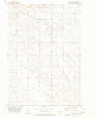
1977 Map of Castle Rock
USGS Topo · Published 1978About this map
Castle Rock rises as the dominant landmark of this Butte County landscape, anchoring a wide expanse of prairie drainage systems. The terrain is defined by an intricate network of seasonal waterways, including Frog Creek, Buck Pasture Creek, and the various forks of Willow Creek, which converge as they flow through the open range. This 1970s survey captures a transition point in the local geography, where isolated ranching outposts like Schummer sit far from the primary roads. A solitary Radio Tower near the northern boundary serves as a modern navigational marker in an area otherwise characterized by vast stretches of pastureland and subtle elevation changes. The map provides a clear picture of the ranching infrastructure of the era, recording the exact placement of fence lines, small reservoirs, and the unimproved tracks that connect these remote South Dakota homesteads.
Find a feature on this map
9 named features on this map. Tap any name to fly to it.
Don’t see what you’re looking for? This feature index may not catch every label — zoom into the map to look around manually.
Map Details
Editions of this 1977 Castle Rock Map
This is the sole edition of this map. No revisions or reprints were ever made.
Other maps of this area

1906 · Two Top
USGS Topo · 1:62,500

1907 · Belle Fourche
USGS Topo · 1:125,000

1913 · Newell
USGS Topo · 1:125,000

1935 · Hoover
USGS Topo · 1:125,000

1935 · Harding
USGS Topo · 1:125,000

1953 · Rapid City
USGS Topo · 1:250,000

1954 · Lemmon
USGS Topo · 1:250,000

1957 · Lemmon
USGS Topo · 1:250,000

1957 · Rapid City
USGS Topo · 1:250,000
1965 · Two Top Butte East
USGS Topo · 1:24,000