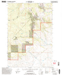
1995 Map of Castle Town
USGS Topo · Published 1997About this map
Castle Town and the neighboring settlement of Robinson serve as the focal points for this mid-1990s survey of the Castle Mountains within the Lewis and Clark National Forest. The landscape is deeply defined by a legacy of resource extraction, with numerous named workings such as the Belle of the Castle Mine, Iron Chief Mine, and Cumberland Mine dotting the terrain. The infrastructure of a previous era is still visible through the Old Railroad Grade that winds through the southeastern portion of the map near Alabaugh Creek. High-elevation landmarks like Castle Mountain and Castle Lake overlook a complex network of drainages, including Boulder Creek and Warm Springs Creek. The presence of the Castle Cem provides a specific point of interest for genealogists tracing the families connected to these remote mountain outposts.
Find a feature on this map
37 named features on this map. Tap any name to fly to it.
Don’t see what you’re looking for? This feature index may not catch every label — zoom into the map to look around manually.
Map Details
Editions of this 1995 Castle Town Map
2 editions found
Other maps of this area

1886 · Little Belt Mts.
USGS Topo · 1:250,000

1894 · Little Belt Mts.
USGS Topo · 1:250,000

1897 · Little Belt Mts.
USGS Topo · 1:250,000

1898 · Little Belt Mts.
USGS Topo · 1:250,000

1902 · Little Belt Mts.
USGS Topo · 1:250,000

1948 · White Sulphur Springs
USGS Topo · 1:250,000

1951 · Hamen
USGS Topo · 1:24,000
1951 · Ringling
USGS Topo · 1:24,000

1951 · Rimrock Divide
USGS Topo · 1:24,000

1958 · White Sulphur Springs
USGS Topo · 1:250,000