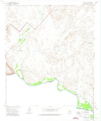
1971 Map of Castolon
USGS Topo · Published 1974About this map
The Rio Grande carves a dramatic international boundary through the southern reaches of Big Bend National Park, as documented in this early 1970s survey. This arid landscape is defined by the confluence of Terlingua Creek and Alamo Creek with the river, where several historic sites are clustered. The settlement of Castolon and the ruins at Terlingua Abaja stand as significant cultural landmarks, supported by utilitarian features like the Gaging Sta and nearby Gravel Pits.
Find a feature on this map
26 named features on this map. Tap any name to fly to it.
Don’t see what you’re looking for? This feature index may not catch every label — zoom into the map to look around manually.
Map Details
Editions of this 1971 Castolon Map
2 editions found
Other maps of this area

1903 · Chisos Mountains
USGS Topo · 1:125,000

1903 · Terlingua
USGS Topo · 1:125,000

1904 · Terlingua
USGS Topo · 1:125,000

1905 · Chisos Mountains
USGS Topo · 1:125,000

1959 · Emory Peak
USGS Topo · 1:250,000

1965 · Emory Peak
USGS Topo · 1:250,000

1971 · Terlingua
USGS Topo · 1:24,000

1971 · Cerro Castellan
USGS Topo · 1:24,000

1971 · Amarilla Mountain
USGS Topo · 1:24,000
1971 · Tule Mountain
USGS Topo · 1:24,000