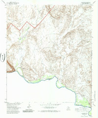
1971 Map of Castolon
USGS Topo · Published 1985About this map
Terlingua Abaja and Castolon sit along the northern banks of the Rio Grande in this 1971 study of the Big Bend region. The landscape is defined by the sharp transition from the Mesa de Anguila to the deep cut of Santa Elena Canyon, where the international boundary between the United States and Mexico follows the river's path. Traces of human activity are scattered across the desert floor, indicated by various Ruins and a Cem near the confluence of Terlingua Creek.
Find a feature on this map
27 named features on this map. Tap any name to fly to it.
Don’t see what you’re looking for? This feature index may not catch every label — zoom into the map to look around manually.
Map Details
Editions of this 1971 Castolon Map
2 editions found
Other maps of this area

1903 · Chisos Mountains
USGS Topo · 1:125,000

1903 · Terlingua
USGS Topo · 1:125,000

1904 · Terlingua
USGS Topo · 1:125,000

1905 · Chisos Mountains
USGS Topo · 1:125,000

1959 · Emory Peak
USGS Topo · 1:250,000

1965 · Emory Peak
USGS Topo · 1:250,000

1971 · Terlingua
USGS Topo · 1:24,000

1971 · Cerro Castellan
USGS Topo · 1:24,000

1971 · Amarilla Mountain
USGS Topo · 1:24,000
1971 · Tule Mountain
USGS Topo · 1:24,000