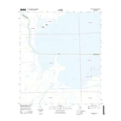
2015 Map of Catahoula Bay
USGS Topo · Published 2015About this map
Lake Salvador and the expansive marshlands of south Louisiana dominate this 2015 survey, where the border between St. Charles Parish and Lafourche Parish winds through a complex network of wetlands. The landscape is defined by its watery transit routes, ranging from the major commercial corridor of the Intracoastal Waterway and Harvey Canal Number Two to smaller, winding channels like Bayou des Allemands and Bayou Matherne. Small coastal settlements and camps, including Tabatiere Perdue, Chaudiere Casse, and Camardelle, are situated along these natural levees and ridges. To the east, the shoreline of Catahoula Bay is punctuated by Point Chicot and Shell Beach, illustrating the fragile transition between the open waters of the Gulf influence and the inner bayous of the delta.
Find a feature on this map
31 named features on this map. Tap any name to fly to it.
Don’t see what you’re looking for? This feature index may not catch every label — zoom into the map to look around manually.
Map Details
Editions of this 2015 Catahoula Bay Map
This is the sole edition of this map. No revisions or reprints were ever made.
Other maps of this area

1891 · Hahnville
USGS Topo · 1:62,500

1891 · New Orleans
USGS Topo · 1:62,500

1892 · Barataria
USGS Topo · 1:62,500

1892 · Cut-Off
USGS Topo · 1:62,500

1932 · New Orleans SW
USGS Topo · 1:31,680

1932 · Hahnville SW
USGS Topo · 1:31,680

1939 · Cut-Off
USGS Topo · 1:62,500
1940 · Allemands
USGS Topo · 1:31,680

1941 · Cut-Off
USGS Topo · 1:62,500

1941 · Barataria
USGS Topo · 1:62,500