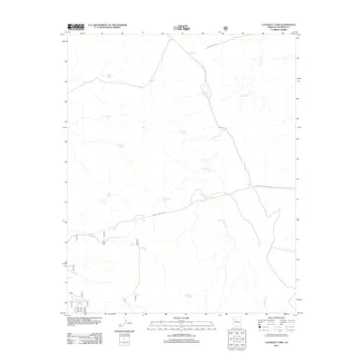
2012 Map of Cataract Tank
USGS Topo · Published 2012About this map
Cataract Cr carves a winding path through this corner of the Coconino plateau, where life and movement are dictated by the scarce presence of water. The landscape is defined by its network of tanks, which are vital infrastructure for ranching and wildlife in this arid region. Notable water sources include Frenchman Tank, Yeager Tank, and Cataract Tank. These catchments are linked by a sparse network of access routes such as Forest Service Road 6 and the W Painted Rock Trl. The map also identifies natural water features like Burro Spring, illustrating how historical land use relied on these specific, named points of relief within the high desert terrain. This 2012 survey provides a precise look at the drainage patterns and essential landmarks that have sustained local operations for generations.
Find a feature on this map
20 named features on this map. Tap any name to fly to it.
Don’t see what you’re looking for? This feature index may not catch every label — zoom into the map to look around manually.
Map Details
Editions of this 2012 Cataract Tank Map
This is the sole edition of this map. No revisions or reprints were ever made.
Other maps of this area

1886 · Chino
USGS Topo · 1:250,000

1891 · Chino
USGS Topo · 1:250,000

1922 · Williams
USGS Topo · 1:125,000

1948 · Williams
USGS Topo · 1:250,000

1954 · Williams
USGS Topo · 1:250,000

1956 · Williams
USGS Topo · 1:250,000

1960 · Williams
USGS Topo · 1:250,000
1960 · Williams
USGS Topo · 1:62,500

1961 · Williams
USGS Topo · 1:250,000

1962 · Valle
USGS Topo · 1:62,500