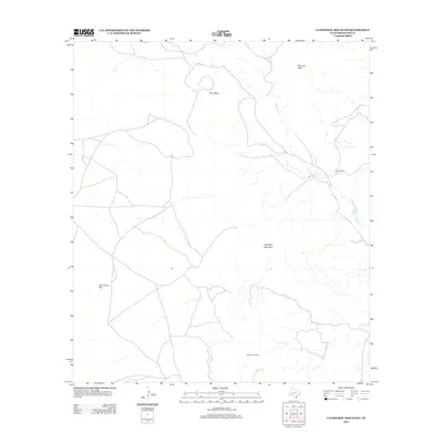
2012 Map of Cathedral Mountain
USGS Topo · Published 2012About this map
Cathedral Mountain and the high desert terrain of Brewster County dominate this 2012 survey, revealing the remote geography of the Texas Trans-Pecos. The landscape is defined by massive topographic features like McIntyre Peak, Terry Mesa, and Marble Mountain, which overlook the seasonal drainage networks of Calamity Cr and Goat Cr. Human activity is centered on ranching, specifically at the Haley Ranch, while the broad expanse of One O One Flat suggests the scale of local cattle grazing operations. The map provides a look at a sparsely populated region where the character of the land dictates the placement of tracks and homesteads, preserving the ranching legacy of West Texas well into the twenty-first century.
Find a feature on this map
8 named features on this map. Tap any name to fly to it.
Don’t see what you’re looking for? This feature index may not catch every label — zoom into the map to look around manually.
Map Details
Editions of this 2012 Cathedral Mountain Map
This is the sole edition of this map. No revisions or reprints were ever made.
Other maps of this area

1895 · Alpine
USGS Topo · 1:125,000

1954 · Fort Stockton
USGS Topo · 1:250,000

1958 · Fort Stockton
USGS Topo · 1:250,000

1972 · Bird Mountain
USGS Topo · 1:24,000

1972 · Paisano
USGS Topo · 1:24,000

1972 · Alpine South
USGS Topo · 1:24,000

1973 · Fort Stockton
USGS Topo · 1:250,000
1983 · Mount Ord
USGS Topo · 1:24,000
1983 · Cactus Flat
USGS Topo · 1:24,000
1983 · Goat Mountain
USGS Topo · 1:24,000