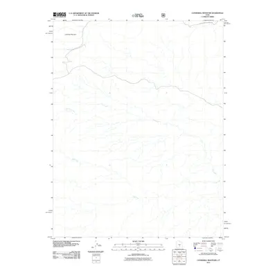
2011 Map of Cathedral Mountain
USGS Topo · Published 2011About this map
Cathedral Mountain stands as the primary landmark in this high-desert landscape within Emery County. The topography is defined by an intricate network of seasonal drainages, most notably Polk Creek and Deep Creek, which carve their way through the terrain toward the southern reaches of the map. A small section of Canyon Lands National Park is visible along the northern border, marking the transition into federally protected wilderness. The drainage patterns of Bullberry Creek and its tributaries reveal a complex erosional environment typical of the Colorado Plateau, where the presence of water is transient but instrumental in shaping the earth.
Find a feature on this map
5 named features on this map. Tap any name to fly to it.
Don’t see what you’re looking for? This feature index may not catch every label — zoom into the map to look around manually.
Map Details
Editions of this 2011 Cathedral Mountain Map
This is the sole edition of this map. No revisions or reprints were ever made.
Other maps of this area

1885 · Fish Lake
USGS Topo · 1:250,000

1896 · Fish Lake
USGS Topo · 1:250,000

1952 · Notom 2 NW
USGS Topo · 1:24,000

1952 · Notom 2 SE
USGS Topo · 1:24,000

1952 · Notom 2 SW
USGS Topo · 1:24,000

1952 · Notom 2 NE
USGS Topo · 1:24,000

1952 · Notom 1 SW
USGS Topo · 1:24,000

1952 · Torrey
USGS Topo · 1:62,500

1954 · Fruita
USGS Topo · 1:62,500
1954 · Notom 1 NW
USGS Topo · 1:24,000