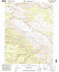
2001 Map of Cathedral Mountain
USGS Topo · Published 2003About this map
Capitol Reef National Park dominates this terrain, showcasing the dramatic monocline of the Waterpocket Fold as it appeared at the turn of the 21st century. The map provides precise detail of the high desert landscape, where elevation changes are marked by distinct geological features like Cathedral Mountain and Needle Mountain. Access to these remote stretches is traced through The Hartnet and Hartnet Draw, routes that lead past crucial water sources such as South Desert Spring and Ring Water Spring. To the south and west, the boundary with Fishlake National Forest indicates the transition into protected highlands. Geologists and surveyors can trace the complex drainage patterns of Middle Desert Wash and Polk Creek, while the presence of the Upper Cathedral Valley Overlook highlights the area's significance for land management and public observation.
Find a feature on this map
26 named features on this map. Tap any name to fly to it.
Don’t see what you’re looking for? This feature index may not catch every label — zoom into the map to look around manually.
Map Details
Editions of this 2001 Cathedral Mountain Map
This is the sole edition of this map. No revisions or reprints were ever made.
Other maps of this area

1885 · Fish Lake
USGS Topo · 1:250,000

1896 · Fish Lake
USGS Topo · 1:250,000

1952 · Notom 2 NW
USGS Topo · 1:24,000

1952 · Notom 2 SE
USGS Topo · 1:24,000

1952 · Notom 2 SW
USGS Topo · 1:24,000

1952 · Notom 2 NE
USGS Topo · 1:24,000

1952 · Notom 1 SW
USGS Topo · 1:24,000

1952 · Torrey
USGS Topo · 1:62,500

1954 · Fruita
USGS Topo · 1:62,500
1954 · Notom 1 NW
USGS Topo · 1:24,000