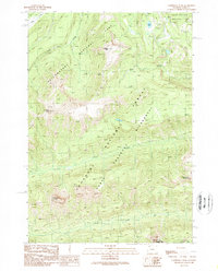
1989 Map of Cathedral Peak
USGS Topo · Published 1989About this map
Yellowstone National Park and the high elevations of the Shoshone National Forest converge on this 1980s topographic record. The landscape is dominated by the steep, sharp profiles of the Absaroka Range, including Cathedral Peak and Pyramid Peak, which rise above a network of drainages such as Mist Creek and Bear Creek. A lengthy Pack Trail serves as the primary artery through the North Absaroka Wilderness, connecting the lower valleys to high points like Cody Peak near the southern boundary. This map captures the territory before modern recreational shifts, emphasizing the isolation of Frost Lake and the difficult approaches to Silvertip Peak. The absence of roads underscores the region's character as a strictly preserved wilderness area where traditional trail systems remain the only way to navigate the high-country terrain.
Find a feature on this map
14 named features on this map. Tap any name to fly to it.
Don’t see what you’re looking for? This feature index may not catch every label — zoom into the map to look around manually.
Map Details
Editions of this 1989 Cathedral Peak Map
This is the sole edition of this map. No revisions or reprints were ever made.
Other maps of this area

1885 · Lake
USGS Topo · 1:125,000

1886 · Canyon
USGS Topo · 1:125,000

1893 · Ishawooa
USGS Topo · 1:125,000

1895 · Ishawooa
USGS Topo · 1:125,000

1895 · Canyon
USGS Topo · 1:125,000

1895 · Lake
USGS Topo · 1:125,000

1896 · Lake
USGS Topo · 1:125,000

1896 · Canyon
USGS Topo · 1:125,000

1896 · Crandall Creek
USGS Topo · 1:125,000

1899 · Crandall
USGS Topo · 1:125,000