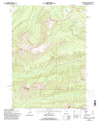
1991 Map of Cathedral Peak
USGS Topo · Published 1996About this map
Yellowstone National Park and the North Absaroka Wilderness meet in this 1991 survey, which documents the remote alpine divide of Northwest Wyoming. The landscape is defined by the high-elevation boundary between the park and the Shoshone National Forest, marked by a series of prominent summits including Pyramid Peak, Cathedral Peak, and Silvertip Peak. These peaks form a dramatic drainage divide for numerous headwater streams, such as Mist Creek and Cold Creek flowing west into the park, while Bear Creek and Jones Creek descend eastward into the wilderness.
Find a feature on this map
17 named features on this map. Tap any name to fly to it.
Don’t see what you’re looking for? This feature index may not catch every label — zoom into the map to look around manually.
Map Details
Editions of this 1991 Cathedral Peak Map
This is the sole edition of this map. No revisions or reprints were ever made.
Other maps of this area

1885 · Lake
USGS Topo · 1:125,000

1886 · Canyon
USGS Topo · 1:125,000

1893 · Ishawooa
USGS Topo · 1:125,000

1895 · Ishawooa
USGS Topo · 1:125,000

1895 · Canyon
USGS Topo · 1:125,000

1895 · Lake
USGS Topo · 1:125,000

1896 · Lake
USGS Topo · 1:125,000

1896 · Canyon
USGS Topo · 1:125,000

1896 · Crandall Creek
USGS Topo · 1:125,000

1899 · Crandall
USGS Topo · 1:125,000