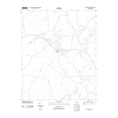
2010 Map of Catherine Lake
USGS Topo · Published 2010About this map
Lake Catherine and the small settlement of Catherine Lake anchor this 2010 topographic study of Onslow County, where the landscape is defined by the winding course of Southwest Creek. The area north of the lake is marked by the presence of Albert J Ellis Airport, with its runways and access roads like Albert Ellis Airport Rd cutting through the rural terrain. The mapping shows a network of local roads named for prominent families and landmarks, such as Ben Williams Rd, Jim Blake Rd, and Foy Lockamy Rd, which suggest the deep-rooted agricultural and local history of this coastal plain region. To the east, the drainage patterns of the New River and Blue Creek shape the low-lying geography, while numerous smaller routes like Union Chapel Church Rd and Rhodestown Rd connect the scattered homesteads and woodland tracts.
Find a feature on this map
38 named features on this map. Tap any name to fly to it.
Don’t see what you’re looking for? This feature index may not catch every label — zoom into the map to look around manually.
Map Details
Editions of this 2010 Catherine Lake Map
This is the sole edition of this map. No revisions or reprints were ever made.
Other maps of this area

1943 · Jacksonville
USGS Topo · 1:62,500

1948 · Maple Hill
USGS Topo · 1:62,500

1948 · New River
USGS Topo · 1:62,500

1948 · Richlands
USGS Topo · 1:62,500

1952 · Jacksonville South
USGS Topo · 1:24,000

1953 · Beaufort
USGS Topo · 1:250,000

1954 · Beaufort
USGS Topo · 1:250,000

1965 · Richlands
USGS Topo · 1:62,500

1972 · Beaufort
USGS Topo · 1:250,000
1975 · Jacksonville NW
USGS Topo · 1:24,000