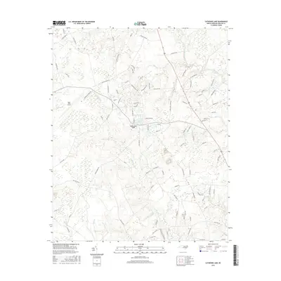
2016 Map of Catherine Lake
USGS Topo · Published 2016About this map
Lake Catherine and the settlement of Catherine Lake anchor this Onslow County landscape, where the coastal plain begins to transition toward the interior. The area is defined by the drainage systems of Southwest Cr and the upper reaches of the New River, with Deep Run cutting through the southwestern portion of the sheet. Modern infrastructure is represented by the Albert J Ellis Airport, while local history is etched into the road network with names like Bannermans Mill Rd and Indian Cave Dr, suggesting former industrial and geographic landmarks. The map shows a region of low-lying wetlands and bays, such as Morgan Bay, interspersed with a growing network of residential lanes and agricultural land typical of eastern North Carolina in the early 21st century.
Find a feature on this map
96 named features on this map. Tap any name to fly to it.
Don’t see what you’re looking for? This feature index may not catch every label — zoom into the map to look around manually.
Map Details
Editions of this 2016 Catherine Lake Map
This is the sole edition of this map. No revisions or reprints were ever made.
Other maps of this area

1943 · Jacksonville
USGS Topo · 1:62,500

1948 · Maple Hill
USGS Topo · 1:62,500

1948 · New River
USGS Topo · 1:62,500

1948 · Richlands
USGS Topo · 1:62,500

1952 · Jacksonville South
USGS Topo · 1:24,000

1953 · Beaufort
USGS Topo · 1:250,000

1954 · Beaufort
USGS Topo · 1:250,000

1965 · Richlands
USGS Topo · 1:62,500

1972 · Beaufort
USGS Topo · 1:250,000
1975 · Jacksonville NW
USGS Topo · 1:24,000