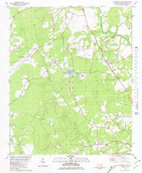
1980 Map of Catherine Lake
USGS Topo · Published 1981About this map
The low-lying coastal plains of Onslow County are defined by the winding course of Southwest Creek and its many tributaries, such as Deep Run and Blue Creek. Centered on the community of Catherine Lake, the landscape at the start of the 1980s reveals a rural texture shaped by traditional congregations and modern infrastructure. The presence of numerous cemeteries and established houses of worship, including Union Chapel Ch, Richlands Ch, and Antioch Ch, provides a clear footprint for genealogical research in this part of North Carolina.
Find a feature on this map
22 named features on this map. Tap any name to fly to it.
Don’t see what you’re looking for? This feature index may not catch every label — zoom into the map to look around manually.
Map Details
Editions of this 1980 Catherine Lake Map
This is the sole edition of this map. No revisions or reprints were ever made.
Other maps of this area

1943 · Jacksonville
USGS Topo · 1:62,500

1948 · Maple Hill
USGS Topo · 1:62,500

1948 · New River
USGS Topo · 1:62,500

1948 · Richlands
USGS Topo · 1:62,500

1952 · Jacksonville South
USGS Topo · 1:24,000

1953 · Beaufort
USGS Topo · 1:250,000

1954 · Beaufort
USGS Topo · 1:250,000

1965 · Richlands
USGS Topo · 1:62,500

1972 · Beaufort
USGS Topo · 1:250,000
1975 · Jacksonville NW
USGS Topo · 1:24,000