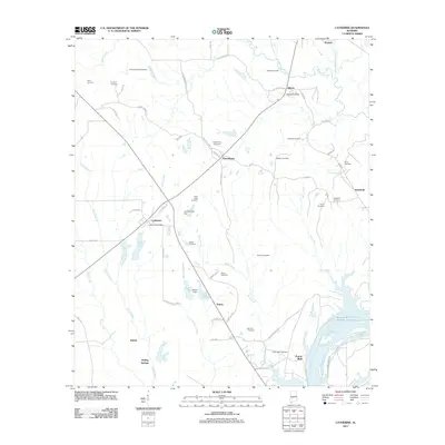
2011 Map of Catherine
USGS Topo · Published 2011About this map
Prairie Bluff stands as a prominent historical landmark on the banks of the William "Bill" Dannelly Reservoir, anchoring this rural Wilcox County landscape. The settlement pattern is defined by a series of small, dispersed communities including Gastonburg, Catherine, and Alberta, each connected by a network of local routes like Chitlin Switch Rd and Walnut St. This area is particularly rich in family and community history, evidenced by more than a dozen documented burial sites such as the Rehoboth Cemetery, Welcome Cemetery, and the Boiling Spring Cemetery. The topography is etched by numerous watercourses, with Shell Creek and Mill Creek winding toward the river, while infrastructure like the Alberta Post Office and the Joe Harrison Dam reflect the local civic and industrial footprint of the early 21st century.
Find a feature on this map
64 named features on this map. Tap any name to fly to it.
Don’t see what you’re looking for? This feature index may not catch every label — zoom into the map to look around manually.
Map Details
Editions of this 2011 Catherine Map
This is the sole edition of this map. No revisions or reprints were ever made.
Other maps of this area

1953 · Montgomery
USGS Topo · 1:250,000

1956 · Montgomery
USGS Topo · 1:250,000

1957 · Montgomery
USGS Topo · 1:250,000

1968 · Thomaston East
USGS Topo · 1:24,000

1968 · Safford
USGS Topo · 1:24,000

1968 · Central Mills
USGS Topo · 1:24,000

1974 · Crumptonia
USGS Topo · 1:24,000

1974 · Catherine
USGS Topo · 1:24,000
1974 · Lee Long Bridge
USGS Topo · 1:24,000
1974 · Camden North
USGS Topo · 1:24,000