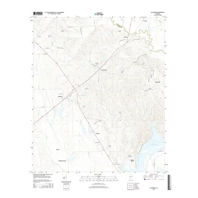
2014 Map of Catherine
USGS Topo · Published 2014About this map
Prairie Bluff stands as a significant point of interest near the banks of the Alabama River, marking a site of deep historical roots in Wilcox County. This interior coastal plain landscape is defined by the winding course of Chilatchee Creek and the expansive William 'Bill' Dannelly Reservoir. The map reveals a high density of family and community burial sites, including the Bolling Spring Cem, Gastonburg Cem, and the Prairie Bluff Cem, which serve as vital markers for genealogical research in this rural region. Settlements such as Catherine, Gastonburg, and Boiling Springs are connected by a network of local routes like Al-5 and the uniquely named Chitlin Switch Rd. The presence of numerous small drainages like Shell Cr and Dixon Cr feeding into the river system illustrates the traditional agricultural and water-dependent character of the area.
Find a feature on this map
65 named features on this map. Tap any name to fly to it.
Don’t see what you’re looking for? This feature index may not catch every label — zoom into the map to look around manually.
Map Details
Editions of this 2014 Catherine Map
This is the sole edition of this map. No revisions or reprints were ever made.
Other maps of this area

1953 · Montgomery
USGS Topo · 1:250,000

1956 · Montgomery
USGS Topo · 1:250,000

1957 · Montgomery
USGS Topo · 1:250,000

1968 · Thomaston East
USGS Topo · 1:24,000

1968 · Safford
USGS Topo · 1:24,000

1968 · Central Mills
USGS Topo · 1:24,000

1974 · Crumptonia
USGS Topo · 1:24,000

1974 · Catherine
USGS Topo · 1:24,000
1974 · Lee Long Bridge
USGS Topo · 1:24,000
1974 · Camden North
USGS Topo · 1:24,000