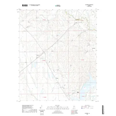
2018 Map of Catherine
USGS Topo · Published 2018About this map
Prairie Bluff stands as a significant historical focal point where the Alabama River meets the William 'Bill' Dannelly Reservoir. This 2018 survey reveals a landscape deeply rooted in family history, evidenced by a high density of small cemeteries such as Boiling Spring Cem, Gastonburg Cem, and Prairie Bluff Cem that mark the holdings of early Wilcox County settlers. The interior geography is defined by a network of creeks including Chilatchee Creek and Shell Cr, which drain the lowlands between the settlements of Catherine and Alberta. Local names like Chitlin Switch Rd and Prairie Mission Rd hint at the rural social fabric and navigation routes of the Black Belt region. The map provides a contemporary view of these established communities, showing how modern county roads now connect what were once isolated river landings and crossroads hamlets.
Find a feature on this map
62 named features on this map. Tap any name to fly to it.
Don’t see what you’re looking for? This feature index may not catch every label — zoom into the map to look around manually.
Map Details
Editions of this 2018 Catherine Map
This is the sole edition of this map. No revisions or reprints were ever made.
Other maps of this area

1953 · Montgomery
USGS Topo · 1:250,000

1956 · Montgomery
USGS Topo · 1:250,000

1957 · Montgomery
USGS Topo · 1:250,000

1968 · Thomaston East
USGS Topo · 1:24,000

1968 · Safford
USGS Topo · 1:24,000

1968 · Central Mills
USGS Topo · 1:24,000

1974 · Crumptonia
USGS Topo · 1:24,000

1974 · Catherine
USGS Topo · 1:24,000
1974 · Lee Long Bridge
USGS Topo · 1:24,000
1974 · Camden North
USGS Topo · 1:24,000