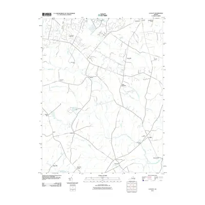
2011 Map of Catlett
USGS Topo · Published 2011About this map
Catlett and Casanova anchor this portion of northern Virginia, where the landscape is defined by the headwaters of numerous runs and branches. The area is marked by established community centers like Greenwich and Auburn, alongside smaller crossroads such as Godfreys Corner and Oak Tree Corner. Local infrastructure is prominent, featuring the Catlett Post Office and Calverton Post Office, while the agricultural and recreational character of the land is visible through Springhill Farm Pond and the larger Lake Brittle, which is held by the Lake Brittle Dam. Historic family and community connections are preserved at sites like the Greenwich Cemetery and Poplar Forks Cemetery. The transport network shows a mix of historical routes like Old Dumfries Rd and Old Auburn Rd, alongside modern developments such as Skyview Airport. Natural features like Luntsfords Mountain and Baldwin Ridge provide the elevation that dictates the flow of Kettle Run and Cedar Run toward the southeast.
Find a feature on this map
75 named features on this map. Tap any name to fly to it.
Don’t see what you’re looking for? This feature index may not catch every label — zoom into the map to look around manually.
Map Details
Editions of this 2011 Catlett Map
This is the sole edition of this map. No revisions or reprints were ever made.
Other maps of this area

1894 · Warrenton
USGS Topo · 1:125,000

1894 · Warrenton
USGS Topo · 1:62,500

1927 · Remington
USGS Topo · 1:48,000

1930 · Warrenton
USGS Topo · 1:62,500

1933 · Middleburg
USGS Topo · 1:62,500

1943 · Catlett
USGS Topo · 1:62,500

1943 · Thorofare Gap
USGS Topo · 1:24,000

1943 · Midland
USGS Topo · 1:24,000

1943 · Marshall
USGS Topo · 1:24,000
1944 · Midland
USGS Topo · 1:31,680