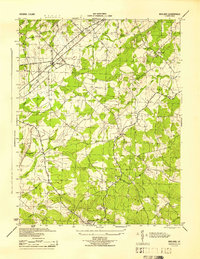
1944 Map of Midland
USGS Topo · Published 1944About this map
Midland sits at the junction of the Southern Railway and a network of rural roads in the northern portion of this wartime survey. The settlement pattern is defined by several small crossroads communities, including Elkrun and Morrisville, which are anchored by local spiritual and educational hubs like Mt Hermon Ch and Mt Pleasant Sch. The landscape is etched by a series of southwest-flowing waterways, most notably Licking Run and Marsh Run, which shaped the early agricultural development of this part of Fauquier County.
Find a feature on this map
18 named features on this map. Tap any name to fly to it.
Don’t see what you’re looking for? This feature index may not catch every label — zoom into the map to look around manually.
Map Details
Editions of this 1944 Midland Map
This is the sole edition of this map. No revisions or reprints were ever made.
Other maps of this area

1887 · Spottsylvania
USGS Topo · 1:125,000

1892 · Spottsylvania
USGS Topo · 1:125,000

1894 · Warrenton
USGS Topo · 1:125,000

1894 · Warrenton
USGS Topo · 1:62,500

1927 · Remington
USGS Topo · 1:48,000

1930 · Warrenton
USGS Topo · 1:62,500

1943 · Catlett
USGS Topo · 1:62,500

1943 · Germanna Bridge
USGS Topo · 1:24,000

1943 · Midland
USGS Topo · 1:24,000
1944 · Somerville
USGS Topo · 1:31,680