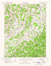
1943 Map of Catlett
USGS Topo · Published 1966About this map
Catlett and its surrounding Piedmont countryside serve as a focal point in this 1943 revision, reflecting the rural character of Fauquier and Prince William counties before post-war suburban expansion. The landscape is defined by the Southern railroad corridor, which links small agricultural hubs and crossroads like Calverton, Nokesville, and Casanova. The map reveals a dense network of country institutions essential to early 20th-century life, including St Stephens Ch, Dunkard Ch, and numerous schoolhouses such as Courtney Sch and Lois Sch.
Find a feature on this map
102 named features on this map. Tap any name to fly to it.
Don’t see what you’re looking for? This feature index may not catch every label — zoom into the map to look around manually.
Map Details
Editions of this 1943 Catlett Map
2 editions found

Other maps of this area

1887 · Spottsylvania
USGS Topo · 1:125,000

1889 · Fredericksburg
USGS Topo · 1:125,000

1890 · Mt. Vernon
USGS Topo · 1:125,000

1891 · Mt. Vernon
USGS Topo · 1:125,000

1892 · Fredericksburg
USGS Topo · 1:125,000

1892 · Spottsylvania
USGS Topo · 1:125,000

1894 · Warrenton
USGS Topo · 1:125,000

1894 · Fredericksburg
USGS Topo · 1:125,000

1894 · Warrenton
USGS Topo · 1:62,500

1894 · Mt. Vernon
USGS Topo · 1:125,000