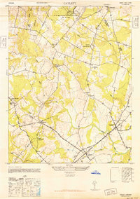
1946 Map of Catlett
USGS Topo · Published 1946About this map
The Southern Railway corridor anchors this portion of Fauquier County, linking the rural hubs of Casanova, Calverton, and Catlett during the mid-1940s. The landscape is a network of small agricultural settlements and social centers, evidenced by the numerous local institutions such as Grace Ch, St Stephens Ch, and the Turkey Run Sch. A notable landmark in the northern reaches is Vint Hill Farm, designated as a U S Military Reservation at the time of this survey.
Find a feature on this map
29 named features on this map. Tap any name to fly to it.
Don’t see what you’re looking for? This feature index may not catch every label — zoom into the map to look around manually.
Map Details
Editions of this 1946 Catlett Map
This is the sole edition of this map. No revisions or reprints were ever made.
Other maps of this area

1894 · Warrenton
USGS Topo · 1:125,000

1894 · Warrenton
USGS Topo · 1:62,500

1927 · Remington
USGS Topo · 1:48,000

1930 · Warrenton
USGS Topo · 1:62,500

1933 · Middleburg
USGS Topo · 1:62,500

1943 · Catlett
USGS Topo · 1:62,500

1943 · Thorofare Gap
USGS Topo · 1:24,000

1943 · Midland
USGS Topo · 1:24,000

1943 · Marshall
USGS Topo · 1:24,000
1944 · Midland
USGS Topo · 1:31,680