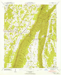
1946 Map of Catlett
USGS Topo · Published 1962About this map
Taylor Ridge bisects this section of Walker County, Georgia, serving as a prominent north-south divide between Tennessee Valley and the Armuchee Valley. The landscape is a network of ridges and hollows, such as Mineral Spring Hollow and Milan Hollow, where early mid-century rural life was anchored by small crossroads like Catlett and Naomi. Much of the eastern terrain falls within the Chattahoochee National Forest, which includes the locally significant Shaw Gap and Maddox Gap. For family historians, the sheet is exceptionally well-indexed with localized landmarks, including Mt Zion Ch, Hickory Hill Sch, and several family cemeteries such as Goodram Cem and Bryan Cem. The road system, notably the Lookout Mountain Scenic Highway and Alabama Road, reflects the traditional transit routes through these gaps before modern interstate expansion.
Find a feature on this map
70 named features on this map. Tap any name to fly to it.
Don’t see what you’re looking for? This feature index may not catch every label — zoom into the map to look around manually.
Map Details
Editions of this 1946 Catlett Map
2 editions found
Other maps of this area

1886 · Ringgold
USGS Topo · 1:125,000

1892 · Ringgold
USGS Topo · 1:125,000

1935 · Catlett
USGS Topo · 1:24,000

1935 · Villanow
USGS Topo · 1:24,000

1935 · Nickajack Gap
USGS Topo · 1:24,000

1935 · Tunnel Hill
USGS Topo · 1:24,000

1936 · Kensington
USGS Topo · 1:24,000

1936 · Estelle
USGS Topo · 1:24,000
1943 · Tunnel Hill
USGS Topo · 1:24,000

1946 · Kensington
USGS Topo · 1:24,000