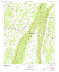
1946 Map of Catlett
USGS Topo · Published 1975About this map
Taylor Ridge and Dick Ridge dominate this Northwest Georgia landscape shortly after World War II, defining the narrow corridors of the Armuchee Valley and the Tennessee Valley Divide. The map documents a predominantly rural, ridge-and-valley settlement pattern where small community centers like Catlett and Naomi are anchored by local institutions. Numerous schools and churches, such as Hickory Hill Sch, Corinth Sch, and Mt Zion Ch, are scattered along the foothills and gaps. The rugged geography is further detailed through family-named landmarks like Maddox Gap and Smith Gap, along with a dense network of hollows including Mineral Spring Hollow and Walden Hollow. Large portions of the eastern terrain fall within the Chattahoochee National Forest, while the northern section features the Lookout Mtn Scenic Highway and the Old Alabama Road, tracing historic transit routes through the hills.
Find a feature on this map
62 named features on this map. Tap any name to fly to it.
Don’t see what you’re looking for? This feature index may not catch every label — zoom into the map to look around manually.
Map Details
Editions of this 1946 Catlett Map
2 editions found
Other maps of this area

1886 · Ringgold
USGS Topo · 1:125,000

1892 · Ringgold
USGS Topo · 1:125,000

1935 · Catlett
USGS Topo · 1:24,000

1935 · Villanow
USGS Topo · 1:24,000

1935 · Nickajack Gap
USGS Topo · 1:24,000

1935 · Tunnel Hill
USGS Topo · 1:24,000

1936 · Kensington
USGS Topo · 1:24,000

1936 · Estelle
USGS Topo · 1:24,000
1943 · Tunnel Hill
USGS Topo · 1:24,000

1946 · Kensington
USGS Topo · 1:24,000