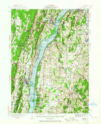
1934 Map of Catskill
USGS Topo · Published 1965About this map
The Hudson River serves as the central artery for this mid-1930s landscape, connecting bustling riverfront towns like Saugerties and Catskill. The region's industrial and maritime heritage is visible through features such as Burden Dock and Washburn Dock, while the newly surveyed Rip Van Winkle Bridge spans the water near Rogers Island. This era captures a transition from traditional river life to a more connected valley, shown by the parallel tracks of the New York Central Railroad and the historic Albany Post Road.
Find a feature on this map
126 named features on this map. Tap any name to fly to it.
Don’t see what you’re looking for? This feature index may not catch every label — zoom into the map to look around manually.
Map Details
Editions of this 1934 Catskill Map
2 editions found

Other maps of this area

1892 · Kaaterskill
USGS Topo · 1:62,500

1893 · Kaaterskill
USGS Topo · 1:62,500

1893 · Coxsackie
USGS Topo · 1:62,500

1893 · Durham
USGS Topo · 1:62,500

1894 · Coxsackie
USGS Topo · 1:62,500

1894 · Kaaterskill
USGS Topo · 1:62,500

1894 · Durham
USGS Topo · 1:62,500

1895 · Catskill
USGS Topo · 1:62,500

1898 · Rhinebeck
USGS Topo · 1:62,500

1899 · Kaaterskill
USGS Topo · 1:62,500