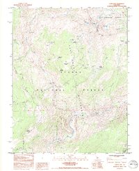
1992 Map of Cattle Mtn
USGS Topo · Published 1995About this map
Cattle Mountain stands as a prominent landmark in this high-altitude landscape where the headwaters of the San Joaquin River system converge. The map documents the convergence of the North Fork San Joaquin River, Middle Fork San Joaquin River, and East Fork San Joaquin River within the protected bounds of the Sierra National Forest and Ansel Adams Wilderness. Numerous alpine meadows, such as Naked Lady Meadow, Indian Meadow, and Earthquake Meadow, punctuate the granite terrain, reflecting a seasonal grazing and transit history. The settlement at Chetwood and the presence of the Granite Stairway suggest the early development of trails and outposts in this region of the High Sierra. Several high lakes, including Gertrude Lake and Ashley Lake, are caught in the high basins beneath peaks like Iron Mountain.
Find a feature on this map
39 named features on this map. Tap any name to fly to it.
Don’t see what you’re looking for? This feature index may not catch every label — zoom into the map to look around manually.
Map Details
Editions of this 1992 Cattle Mtn Map
This is the sole edition of this map. No revisions or reprints were ever made.
Other maps of this area

1901 · Mt. Lyell
USGS Topo · 1:125,000

1904 · Kaiser
USGS Topo · 1:125,000

1947 · Mariposa
USGS Topo · 1:250,000

1948 · Mariposa
USGS Topo · 1:250,000

1953 · Merced Peak
USGS Topo · 1:62,500

1953 · Devils Postpile
USGS Topo · 1:62,500

1953 · Shuteye Peak
USGS Topo · 1:62,500

1953 · Kaiser Peak
USGS Topo · 1:62,500

1957 · Mariposa
USGS Topo · 1:250,000

1963 · Mariposa
USGS Topo · 1:250,000