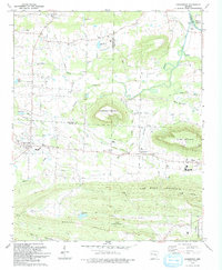
1993 Map of Caulksville
USGS Topo · Published 1993About this map
Horseshoe Mountain and Short Mountain dominate the central landscape of this Logan County region, standing as prominent high ground above the surrounding drainage basins of Sixmile Creek and Hurricane Creek. The settlement pattern in the early 1990s reveals a mix of small rural communities like Etna and Garner alongside the more established town of Paris in the east. An Old Railroad Grade winds through the valley between the peaks, tracing the path of former industrial transport near Carbon City.
Find a feature on this map
42 named features on this map. Tap any name to fly to it.
Don’t see what you’re looking for? This feature index may not catch every label — zoom into the map to look around manually.
Map Details
Editions of this 1993 Caulksville Map
This is the sole edition of this map. No revisions or reprints were ever made.
Other maps of this area

1879 · Mountain Home
USGS Topo · 1:62,500

1887 · Magazine Mountain #1
USGS Topo · 1:62,500

1887 · Magazine Mountain #4
USGS Topo · 1:62,500

1887 · Magazine Mountain #2
USGS Topo · 1:62,500

1887 · Magazine Mountain #3
USGS Topo · 1:62,500

1887 · Magazine Mountain
USGS Topo · 1:62,500

1890 · Magazine Mountain
USGS Topo · 1:125,000

1934 · Booneville
USGS Topo · 1:48,000

1939 · Booneville
USGS Topo · 1:62,500

1956 · Russellville
USGS Topo · 1:250,000