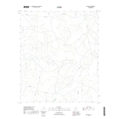
2019 Map of Causey Draw
USGS Topo · Published 2019About this map
The Middle Concho River winds through this arid portion of Irion County, defining a landscape of complex drainage systems and ranching infrastructure. This late-2010s survey illustrates a region shaped by intermittent waterways, where significant features like Causey Draw and Tepee Draw collect runoff from the surrounding high ground. The naming of local routes, such as Momma Pfluger Rd and Bacon Rind Rd, reflects the deep-rooted ranching heritage and family history of West Texas. These secondary roads and 4WD tracks like Lewis Trap Rd provide the primary access to large landholdings, connecting isolated pens and working areas across Antelope Draw and McDowell Draw. Researchers will find a detailed representation of contemporary land use in a territory where the river and its ephemeral tributaries remain the central geographical focus.
Find a feature on this map
13 named features on this map. Tap any name to fly to it.
Don’t see what you’re looking for? This feature index may not catch every label — zoom into the map to look around manually.
Map Details
Editions of this 2019 Causey Draw Map
This is the sole edition of this map. No revisions or reprints were ever made.
Other maps of this area

1921 · Ketchum Mountain
USGS Topo · 1:62,500

1923 · Ketchum Mountain
USGS Topo · 1:62,500

1954 · San Angelo
USGS Topo · 1:250,000

1958 · San Angelo
USGS Topo · 1:250,000

1965 · San Angelo
USGS Topo · 1:250,000

1970 · South Mustang Draw SE
USGS Topo · 1:24,000

1970 · South Mustang Draw NE
USGS Topo · 1:24,000

1973 · Hay Hollow
USGS Topo · 1:24,000
1973 · Bradford Draw
USGS Topo · 1:24,000

1973 · Three Bluff Draw
USGS Topo · 1:24,000