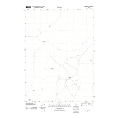
2010 Map of Cave Draw
USGS Topo · Published 2010About this map
Sheep Creek carves a winding path through this corner of Owyhee County, joining the Bruneau River near the eastern edge of the survey. The landscape is characterized by its high-desert water features and distinctive volcanic or erosional landforms, including the isolated Monument Butte and Catholic Butte. The southwestern portion of the sheet opens into Bighorn Country, a name that suggests the local fauna and the character of the terrain.
Find a feature on this map
11 named features on this map. Tap any name to fly to it.
Don’t see what you’re looking for? This feature index may not catch every label — zoom into the map to look around manually.
Map Details
Editions of this 2010 Cave Draw Map
This is the sole edition of this map. No revisions or reprints were ever made.
Other maps of this area

1955 · Twin Falls
USGS Topo · 1:250,000

1956 · Big Hill
USGS Topo · 1:62,500

1956 · Winter Camp
USGS Topo · 1:62,500

1958 · Twin Falls
USGS Topo · 1:250,000

1979 · Stiff Tree Draw
USGS Topo · 1:24,000

1979 · Indian Hot Springs
USGS Topo · 1:24,000

1979 · Blackstone Reservoir
USGS Topo · 1:24,000

1979 · Cave Draw
USGS Topo · 1:24,000
1979 · Buster Butte
USGS Topo · 1:24,000
1979 · Inside Lakes
USGS Topo · 1:24,000