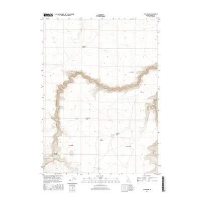
2017 Map of Cave Draw
USGS Topo · Published 2017About this map
The high plateaus of Owyhee County define this 2017 landscape, where the Bruneau River and Sheep Cr have carved deep, winding incisions into the desert floor. The map highlights the sharp relief of the Bruneau Canyon on the eastern edge and the dramatic Big Bend of Sheep Creek in the center, illustrating how water has shaped this arid environment over millennia. Above these drainages, the terrain flattens into expansive high-elevation plains including the Blackstone Desert and J-P Desert. Isolated landmarks such as Monument Butte and Catholic Butte rise above the surrounding flats, serving as navigational anchors in a region otherwise characterized by its vast, open character. Seasonal hydrology is evident through features like Catholic Lake, Ibarinaga Lake, and Big Lake Draw, which mark drainage patterns across the high desert benches between the canyon rims.
Find a feature on this map
17 named features on this map. Tap any name to fly to it.
Don’t see what you’re looking for? This feature index may not catch every label — zoom into the map to look around manually.
Map Details
Editions of this 2017 Cave Draw Map
This is the sole edition of this map. No revisions or reprints were ever made.
Other maps of this area

1955 · Twin Falls
USGS Topo · 1:250,000

1956 · Big Hill
USGS Topo · 1:62,500

1956 · Winter Camp
USGS Topo · 1:62,500

1958 · Twin Falls
USGS Topo · 1:250,000

1979 · Stiff Tree Draw
USGS Topo · 1:24,000

1979 · Indian Hot Springs
USGS Topo · 1:24,000

1979 · Blackstone Reservoir
USGS Topo · 1:24,000

1979 · Cave Draw
USGS Topo · 1:24,000
1979 · Buster Butte
USGS Topo · 1:24,000
1979 · Inside Lakes
USGS Topo · 1:24,000